DiscovAir
Editorial and science-communication work for DiscovAir, a personalised environmental-information service that used Copernicus Atmosphere Monitoring Service data to help people plan trips and outdoor activities in Greece and Cyprus.
Overview
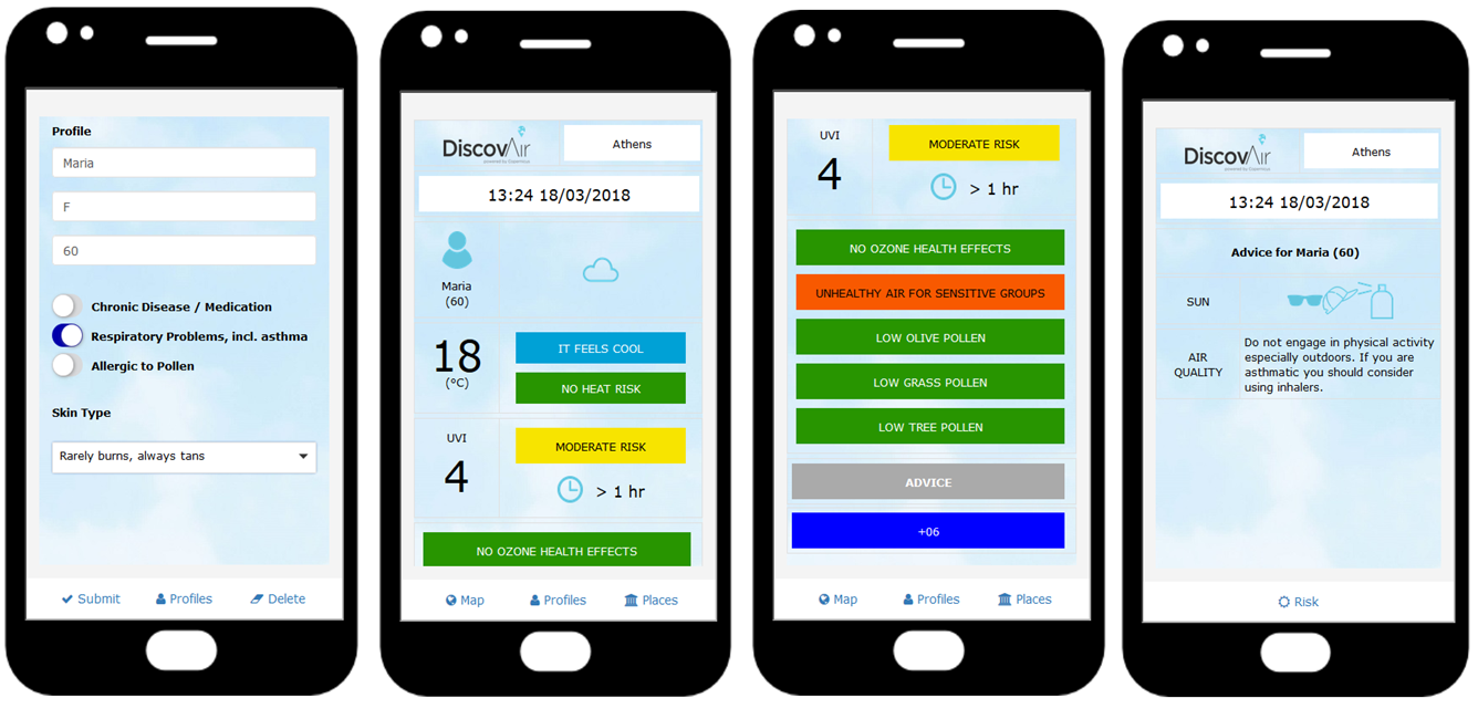
DiscovAir was a personalised environmental-information service designed to help residents and visitors make better-informed decisions about travel, outdoor activity and time spent in Greece and Cyprus.
The service combined the user’s location and preferences with atmospheric and weather information, including air quality, ultraviolet radiation, pollen, temperature, humidity, wind and cloud cover. It then provided tailored advice about comfort and health conditions at a selected location.
I contributed editorial and science-communication work through Design & Data, helping explain how Copernicus atmospheric data could be transformed into practical guidance for everyday life.
The challenge
Environmental conditions can affect travel plans, outdoor activity and personal comfort, but the data behind these conditions are often difficult to interpret.
A traveller may not want to assess ozone concentrations, particulate matter, relative humidity or pollen forecasts directly. They are more likely to ask:
- What will air quality be like at my destination?
- Is this a good time to go outside?
- Are pollen levels likely to aggravate allergies?
- Should I take additional precautions in strong sunlight?
- When would be the most comfortable time to visit a beach, park or city?
DiscovAir addressed these questions by combining forecast information with a user profile, providing advice that was specific to both location and personal needs.
The service
DiscovAir was developed by the National Observatory of Athens in partnership with the Academy of Athens and Evenflow Sprl. It provided assessments of current and forecast conditions for UV index, air quality, temperature and pollen at locations across Greece and Cyprus.
The service was designed for citizens and tourists, helping users organise trips, days out and outdoor activities through location-specific advice and alerts.
It was made available through:
- A mobile application.
- A public website.
- A service portal for tourism operators.
- A service portal for local administrations.
The service portals enabled organisations to access local air-quality information and weather bulletins for their customers, guests and communities. [web:259]
Information provided
DiscovAir combined several environmental variables into advice focused on health, comfort and travel planning.
| Information area | Example use |
|---|---|
| Air quality | Understanding likely exposure to pollution |
| UV index | Planning sun protection and time outdoors |
| Pollen | Managing allergy-related activity choices |
| Temperature | Assessing heat and thermal comfort |
| Humidity and cloud cover | Understanding weather-related comfort |
| Wind and dust aerosols | Supporting activity and travel planning |
The service used CAMS data relating to ozone (\(\mathrm{O_3}\)), particulate matter (\(\mathrm{PM_{2.5}}\) and \(\mathrm{PM_{10}}\)) and birch pollen. It also incorporated temperature, relative humidity, cloud cover, wind speed, dust aerosols and UV-index information. [web:259]
CAMS contribution
The Copernicus Atmosphere Monitoring Service (CAMS) provides atmospheric information on air quality, pollutants, pollen and ultraviolet radiation.
For DiscovAir, CAMS supplied atmospheric-composition data that were updated hourly. These data supported information about current conditions and forecasts for the days ahead.
The service combined CAMS variables with weather data and individual health-risk factors to provide personalised recommendations about the optimum time to visit a location.
CAMS atmospheric information
- Weather conditions
- User location
- Personal health and comfort preferences = Personalised environmental advice